
Snow, Wintry Mix by MidWeek

This was the scene in downtown Lavonia in January 2010 when some 8 inches of snow fell. Forecasters say that much snow is not expected with this system, if we get any at all.
Here we snow again…
North, Northeast Georgia and the Upstate bracing for a significant weather event this week. A winter storm watch has been issued for Northeast Georgia beginning at 6a Tuesday through 7a Thursday morning.
“I think one thing that is making this storm a little bit challenging is that it’s not going to move through the area all at once,” said Meteorologist Harry Geripetritus with the National Weather Service in Greenville-Spartanburg this morning. “Between today and tomorrow we’re going to see just a few small spurts where we could have just some spotty snow or some areas of light snow and sleet.”
Then by Wednesday, Geripetritus said the main system will hit Northeast Georgia when a strong low pressure system settles over the region.
“As we start getting out to Wednesdsay, we’re going to see a rather strong low pressure system move through,” he said. “And so the precipitation amounts are going to increase. We think that most of that will be falling across the area as snow.”
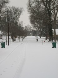
Roberts Drive, Lavonia, January 2010
Geripetritus said the Franklin, Hart, Stephens county area can expect a good accumulation of snow on Wednesday with some freezing rain mixed in. Roads are expected to be slick Wednesday morning as temperatures dip into the low 30s overnight Tuesday.
“As Wednesday goes on and especially into Wednesday evening we could see that turn over to sleet and maybe even some freezing rain late,” Geripetritus said. “We do expect we’ll see some significant accumulations of snow. Probably about four to six inches of snow with a little bit of sleet mixed in and we could perhaps see a trace to a tenth of an inch of freezing rain mixed in. So it’s going to be wintry and should become significant by mid-week.”
By Thursday, morning our region should be waking up to dicey conditions on the roads with significant snowfall on the ground. However, the sunshine returns and we begin to warm up by afternoon with temperatures in the mid-40s. Temperatures are expected to be back into the 50’s by the weekend.
Stay with 92.1 Lake Hartwell Radio for the latest on the weather and road conditions as well as closings and delays.