
UPDATED: Sally Expected to Bring Rain Through Thursday Evening
 Northeast Georgia will feel the effects of Hurricane Sally beginning overnight tonight and into Thursday, according to the National Weather Service in Greenville-Spartanburg.
A flash flood watch is now in effect from 8a Thursday morning to 8a Friday morning for our area.
Sally’s outer bands will trek slowly across Franklin and surrounding counties and the Upstate beginning overnight tonight, which according to meteorologist Robbie Munroe, is expected to bring steady, heavy rain to our area.
According to Munroe, the heaviest rainfall will set up early Thursday morning beginning around 5a and continue for most of the day.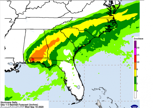
“We’ll see some light to moderate rain bands ahead of it, but once the heavier rain sets in late tonight or early tomorrow morning, that will be fairly persistent moderate to heavy rain with not much breaks,” he said Wednesday morning. “Might be better to say the heavier rain doesn’t set up closer to early morning, like 5 or 6a and it looks like right now will continue through the afternoon hours, possibly into the early evening hours is what we’re looking at right now.”
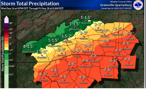
Munroe said our area could see 4-6 inches of rain or more over the period because of the slow-movement of Sally.
Munroe said that is just an estimate right now and that could go down as the storm breaks up and begins to move across the Southeast.
The remnants of Sally are expected to be mostly out of our area by Friday afternoon with a chance for rain Friday morning.
WLHR News will continue to monitor the forecast and bring you the latest weather watches and warnings as they become available.