
Georgia Department of Public Health COVID-19 Daily Status Report For 03/27/20 – Noon
| COVID-19 Confirmed Cases | No. Cases (%) |
|---|---|
| Total | 2001 (100%) |
| Hospitalized | 566(28.29%) |
| Deaths | 64 (3.2%) |
| Lab | Number of Positive Tests | Total Tests |
|---|---|---|
| Commercial Lab | 1739 | 8119 |
| GPHL | 262 | 1746 |
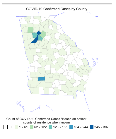
| County | Cases |
|---|---|
| Fulton | 307 |
| Dougherty | 193 |
| Dekalb | 181 |
| Cobb | 144 |
| Gwinnett | 102 |
| Bartow | 98 |
| Carroll | 55 |
| Cherokee | 46 |
| Clayton | 46 |
| Henry | 40 |
| Lee | 35 |
| Clarke | 32 |
| Douglas | 27 |
| Hall | 24 |
| Floyd | 20 |
| Coweta | 19 |
| Fayette | 19 |
| Forsyth | 19 |
| Lowndes | 16 |
| Rockdale | 16 |
| Newton | 15 |
| Mitchell | 14 |
| Gordon | 12 |
| Paulding | 12 |
| Richmond | 11 |
| Spalding | 11 |
| Tift | 11 |
| Troup | 11 |
| Bibb | 10 |
| Chatham | 10 |
| Columbia | 10 |
| Early | 10 |
| Oconee | 10 |
| Polk | 10 |
| Sumter | 10 |
| Houston | 9 |
| Muscogee | 8 |
| Laurens | 7 |
| Worth | 7 |
| Barrow | 6 |
| Glynn | 6 |
| Peach | 6 |
| Terrell | 6 |
| Whitfield | 6 |
| Bryan | 4 |
| Colquitt | 4 |
| Crisp | 4 |
| Effingham | 4 |
| Lumpkin | 4 |
| Pickens | 4 |
| Burke | 3 |
| Butts | 3 |
| Coffee | 3 |
| Irwin | 3 |
| Lamar | 3 |
| Lincoln | 3 |
| Madison | 3 |
| Meriwether | 3 |
| Monroe | 3 |
| Randolph | 3 |
| Thomas | 3 |
| Baldwin | 2 |
| Ben Hill | 2 |
| Calhoun | 2 |
| Camden | 2 |
| Dawson | 2 |
| Decatur | 2 |
| Fannin | 2 |
| Jackson | 2 |
| Jasper | 2 |
| Jones | 2 |
| Miller | 2 |
| Seminole | 2 |
| Tattnall | 2 |
| Turner | 2 |
| Twiggs | 2 |
| Upson | 2 |
| Ware | 2 |
| Washington | 2 |
| Baker | 1 |
| Catoosa | 1 |
| Charlton | 1 |
| Chattooga | 1 |
| Clinch | 1 |
| Dodge | 1 |
| Franklin | 1 |
| Greene | 1 |
| Habersham | 1 |
| Haralson | 1 |
| Harris | 1 |
| Heard | 1 |
| Liberty | 1 |
| Long | 1 |
| Macon | 1 |
| Mcduffie | 1 |
| Morgan | 1 |
| Pierce | 1 |
| Pulaski | 1 |
| Stephens | 1 |
| Taylor | 1 |
| Toombs | 1 |
| White | 1 |
| Wilkes | 1 |
| Unknown | 217 |
*Based on patient county of residence when known
Report generated on: 03/27/2020 11:28:18